The various regions/provinces in Daggerfall can take on a broad range of appearances. From the dry deserts of Alik’r, to the fecund swamps of Totambu, Daggerfall applies local flavour to almost every corner of the map. Different parts of the game world not only have distinct textures for most buildings, but varied plant life as well.
A primary goal for Daggerfall Scout is to faithfully display world maps as they would appear in the game. This is where climate processing comes in. When a city is correctly passed through the climate processer, it will take on the appearance of a desert, swamp, mountainous, or temperate location. Before I could do this, I had to find where Daggerfall itself stored information about a location’s climate, including native plant life. Today’s Visual Diary steps through the process from research to implementation.
 |
A Red Herring
The first place I looked was the map data in WOODS.WLD. Every pixel on the small map data has a corresponding large map chunk. One of the data values in the header for this chunk always corresponds to a ground texture. This seemed like a promising place to start.
After a bit of experimentation, I found the texture value only seemed valid some of the time. In many cases, it was flat out wrong. The city of Sentinel is a good example. The large map chunk for this world pixel reported the ground texture as 302 (temperate), not 2 (desert).
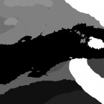
In frustration, I saved out the data into a visual format with intriguing results. Only the far eastern part of the world map, and some of the south, had any definition. The rest was a flat sea of “temperate”. This obviously wasn’t right, so I had to keep looking.
I’m guessing the data visualised to the left is either from an old version of the game world, or used in some as-yet not understood way. |
 |
CLIMATE.PAK
The next place to look was CLIMATE.PAK, which also defines a single pixel that can be overlaid on the standard 1000×500 world map. This data has been known about for some time, but I’ve not looked deeply into how it is used.
The first step was to see what kinds of numbers we’re dealing with. Each climate pixel is a value from 223 to 232. To see this visually, I saved out a series of climate maps, each with a single climate highlighted where it’s used in the world. The screenshot to the left shows climate 226, which covers the mountainous regions of Wrothgaria, Dragontail, and interestingly the Isle of Balfiera. This seemed far more promising. Each climate zone neatly overlaid visually distinct areas of the world.
Once I knew which areas were affected by a particular climate, I fired up Daggerfall and started taking notes. After a few hours of testing, I found Daggerfall always uses the same texture base and plant archive for any given climate value. This allowed me to build a table of which climate pixels uses which texture series for buildings and ground scenery.
If you’ve used Daggerfall Explorer, then you have probably played with my climate texture swaps already. Knowing how to make the swap is one thing. Understanding where the game draws this data from is quite another. With this in place, I was armed to build climate processing into Daggerfall Scout. |
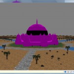 |
Pretty!
New code doesn’t always go to plan. The trees and other ground scenery are processed correctly, but the ground and buildings textures aren’t quite right. Castle Sentinel is particularly attractive.
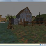
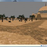
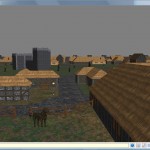
After quickly fixing a few bugs, things start looking better. |
   |
Working Climate Processing
Finally, Daggerfall Scout will build a map using the correct building textures and ground scenery for that climate. This has been confirmed by travelling through Daggerfall with Scout running alongside to many locations in each climate band.
The screenshots to the left show maps using swamp, desert, and mountain climates, with distinct scenery in place.
The next step will be to drop in skies. Once again I need to do some research to find out exactly which skies Daggerfall uses where. I’ll put up another visual diary once I’ve made more progress. |


